
Where there’s smoke, there’s flooding: W&M team studies geology of wildfires
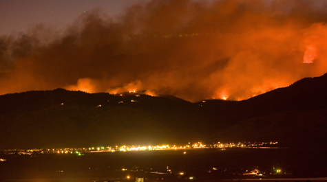
The most destructive wildfire in Colorado’s history began on Sept. 6, 2010. For four days, it burned an area roughly 10 square miles around Fourmile Canyon. It destroyed 168 homes, more than any previous fire in Colorado’s history. Insurance claims totaled an estimated $217 million, making it the state’s most expensive wildfire.
But it wasn’t the fire that made James Kaste, associate professor of geology at William & Mary, want to study Fourmile Canyon. It was the heavy rains that followed it.
“There was this intense wildfire,” Kaste said. “But following it was years of increased rainfall. They had strong thunderstorms in 2011 and 2012 — and then there was a massive flood in 2013. So several scientists began to try to understand how the soils responded to that one-two punch.”
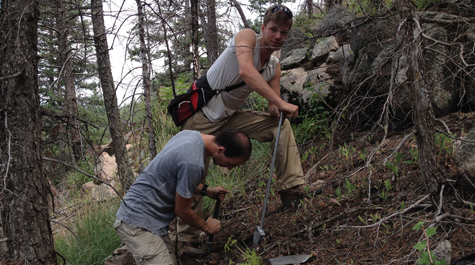
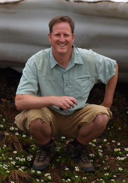 The summer after the flood, Kaste and undergraduate geology major Edward Abrahams '15 traveled to Fourmile Canyon to collect soil samples. The study of soil at the site later became Abrahams’ senior thesis project. The William & Mary team was joined by researchers from Williams College and the University of Connecticut.
Supported by the Keck Geology Consortium, a multi-college undergraduate research initiative, the project was aimed at understanding the geomorphic effects of extreme wildfires followed by catastrophic floods. Abrahams and Kaste’s research will be published in Earth Surface Processes & Landforms, the journal of the British Society for Geomorphology, later this year.
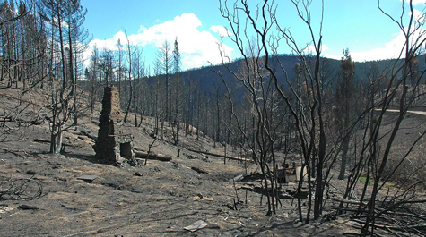
“Our focus was to describe the soil erosion after this fire-flood scenario,” Kaste said. “Precipitation hit the landscape relatively evenly in our study area, so all of the soil had been hit by strong rains, but not all of the soil had been hit by the fire. We analyzed soils from the non-burned and burned areas and used isotopic signatures of erosion to measure how much soil was lost.”
What they found was a relationship between fire and flooding that “has the potential to substantially change future erosion rates” in the region, they later wrote in the study. Their research showed areas that burned hottest experienced an erosion rate around a hundred times higher than the region’s longer-term natural erosion rate.
“The fires change the soil properties,” Kaste explained. Areas with dense vegetation, such as the north-facing slopes of Fourmile Canyon, provide more fuel for wildfires, making the fires burn hotter and faster. An intense, fast-moving fire will burn the organic layer at the soil surface, Kaste said, which effectively makes the soil water repellent. Instead of water soaking the ground, it cuts into it.
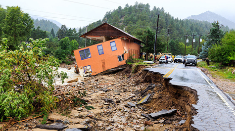
“The soils become hydrophobic,” Kaste said. “So the water does not seep into the ground. When the rains followed that fire, the soils were not able to absorb the water and so it ran off into rivers and roads. Houses were destroyed, property was damaged and cars became part of the sediment load of the rivers.”
Both wildfires and heavy rainstorms are expected to increase in frequency and severity with changing climate conditions, Kaste said. Since 1970, the region’s wildfires have increased fourfold in both frequency and magnitude, while the area burned has increased more than sixfold.
“This is going to be happening a lot more and with a lot more intensity,” Abrahams said. “That’s one of the bigger takeaways I got from this whole experience. It’s important research in terms of looking forward to the future and knowing what the effects will be and how that can help us prevent, or in the very least, mitigate them.”
Kaste says those looking to build homes in the area should keep in mind their proximity to dense forest and running water.
“If you were going to construct a house there,” Kaste said. “You wouldn’t want a forest around you and you would want to be well above the stream valley.”
If not, the homeowner is at risk of experiencing flooding — even if their property survives a wildfire, he said.
“It definitely left me with an appreciation for the effects that fire can have and what the implications are for people living in those places,” Abrahams said. “It gives you an appreciation of the cost of living in such a beautiful place.”