
Structural Geology classes begin series of epic quests through Middle Earth
The Fellowship did not begin the Quest in the Shire; nor did the Quest end in the darkest depths of Mordor.
There was no trekking through the Mines of Moria, and the Plains of Rohan remain untrod, for the present.
But that doesn’t mean it wasn’t epic.
In truth, the Fellowship did not journey far from the Hall of McGlothlin-Street, home of William & Mary’s Department of Geology. It’s a virtual geological quest using an enhanced version of J.R.R. Tolkien’s map of Middle Earth from The Lord of the Rings, coming exactly 80 years after Tolkien’s introduction of Middle Earth to Earth Earth in the 1937 publication of his LOTR prequel, The Hobbit.
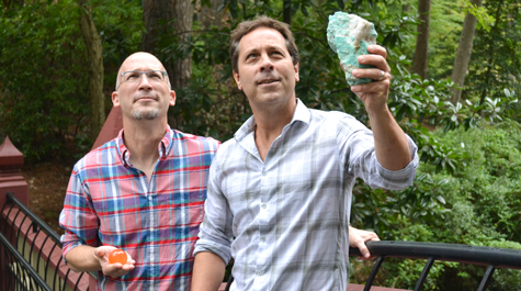
The geography is fake, but the geology is real. Professor Chuck Bailey created a fictitious terrain for the students in his Structural Geology class to use as a project for each of the last 20 years. Structural geology, he explained, is concerned with the architecture of the earth.
“We want our geology students to be able to understand earth structures,” he said. “To understand them, you often have to go to the field to see them in the real world.”
Bailey noted that there is plenty of interesting geology around Williamsburg — but if you’re a structural geologist, all the really good stuff around here is buried.
“We’ve got these lovely estuaries around us. We’re on a gentle plain, primarily covered by sediment,” he explained. “These sediments cover up a lot of the earth structure that I’m so interested in studying.”
 As there’s not much structure around William & Mary, William & Mary geology students must go to the structure. Bailey and other geology faculty take students on field trips, which might be as close as Yorktown and as distant as the fascinating folded rock layers in Oman.
To see earth structure in Virginia, Williamsburg-based geologists have to journey at least to the Richmond area, where the Piedmont begins. There also is good structure to be found west through the Shenandoah Valley and into the Blue Ridge.
“Field trips are an important part of what we do in geology,” Bailey said. “These field experiences are important to understanding structural geology because the earth is complicated. Talking about it in lectures is one thing, but being there in person is important.”
But like Mordor, one doesn’t simply walk into a geological field trip or field research. To get the most out of these on-the-spot experiences, a student has to master a few concepts and skills. In short, Bailey said, a structural geologist has to understand how to read a standard geological map, developing the knack of looking at a two-dimensional geo map and being able to visualize the three-dimensional earth it depicts.
And that’s where the Integrated Structure Project comes in. It’s a set of exercises based on a fictitious terrain in a made-up landscape. The rock samples and the geological situations are real enough to give Structural Geology students the chance to make their own geological maps from scratch.
People often ask Bailey why he doesn’t use examples of real-earth geology to school his Structural Geology students.
“The reason is that when I was a student, if I was given a real geological problem, I’d just go to the library and look the answer up,” he said. “Today, of course, it’s even easier to find those answers. You can just go onto the internet.”
For the past two decades, Bailey has created a “fake, bogus, inauthentic, made-up” research experience for the edification of his Structural Geology classes, which he typically teaches each spring semester. He showed a lunchtime gathering of faculty affiliated with the Environmental Science and Policy Program a sample of one of his “inauthentic” landscapes — Odyssey Island, dotted with references out of Homer.
He said his fictitious geological locales had necessarily become repeated variations on a few themes after 20 years of teaching the course. But, this year Bailey’s Structural Geology classes made their way through Middle Earth, actually a geologically enhanced version of Tolkien’s fanciful map in the university’s Center for Geospatial Analysis (CGA).
It was Rob Rose, director of the CGA, who suggested that Bailey trek his students through Middle Earth. Rose is a big Tolkien fan; he and his wife binge-watch the Lord of the Rings trilogy during a bad-weather weekend each winter.
“One day, we were watching the movies. And I thought, has anyone ever mapped out the route that Frodo took from the Shire to Mordor?” he said. “And do we know if that’s the best route to take? Because that’s a common question we ask with GIS: What’s the best way to get from point A to point B. We do what’s called a least cost path analysis.”
An analysis of the efficiency of Frodo’s route and a determination of the optimum Bag End-to-Orodruin route requires a more sophisticated map than the Tolkien version in the front of the books. Rose talked the matter over with the current CGA fellows, undergraduates who are part of the mission to bring the power of geographic information systems (GIS) throughout William & Mary.
The project required a DEM, or digital elevation model, a 3-D representation of the Earth — or in this case, Middle Earth. The idea of helping to construct a digital representation of the land of the Lord of the Rings was met with the same level of approval among the CGA fellows as a call to second breakfast in Hobbiton.
“It took some working, but we finally had a full-elevation model for Middle Earth,” Rose said. Soon afterwards, he was speaking with Bailey about his Structural Geology DEM, approaching its second decade of revision and getting a little fossilized. “I said, well we have this DEM of Middle Earth now, do you want to use it? It’s a fantastical place. ”
The Middle Earth DEM was first used in Bailey’s spring, 2017 Structural Geology class. Students executed virtual treks across the Cape of Andrast. Andrast is a kind of an out-of-the-way corner of western Middle Earth, sticking between the great ocean Belegaer and the Bay of Belefas. In the Tolkien mythos, Andrast is inhabited by “short, stumpy-bodied men” known variously as Drúedain, Woses or Wild Men of the Woods.
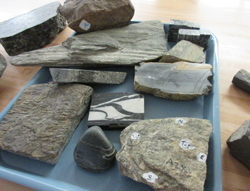
Bailey sent the Structural Geology Fellowship on a Quest from, say, Warg Cove across Dagger Ridge. Their route is dotted with points that correspond to a set of rock samples and segments of a real geological map. The students are tasked with deciphering the geology of each point and how each point relates to the larger map.
Even working with an existing fictional map, Bailey found himself coining nomenclature. Tolkien’s map isn’t nearly fine-scaled enough. Even the CGA’s version has wide swatches left unlabeled.
“I had to make up a bunch of place names,” he said. Bailey freely acknowledges that he’s not a Tolkien authority and gratefully accepts revision of his additions to Middle Earth nomenclature by those with greater elf cred.
For instance, he placed the name “Watermelon Mountains” on an Apennine-like range of peaks that goes down the center of Andrast. It didn’t pass muster.
“One of my nerdy research students had a look at my map and admonished me for missing an original Tolkien geographic name,” Bailey said. “They are known as Druwaith Iaur. I made that change and the Watermelon Mountains are no more.”
Bailey is happy to accommodate such corrections, but he stresses that the purpose of the Fellowship is to advance geology, not mythology. To increase the learning value (while taking advantage of opportunities to make an inside joke), the Quest incorporates the occasional element that would make a hardened Tolkien purist glower like a Nazgul reading flood-warning signs at the Ford of Bruinen.
For example, it’s hard to imagine Tolkien’s Middle Earth containing a ranch operated by Jim Kaste. Kaste, an associate professor of geology, visited the class seeking the help of the Fellowship. He tells them he thinks there’s coal on his spread and needs geologists to find it so he can begin mining it.
The Kaste Ranch is leagues distant from a feline spa operated by geologist Greg Hancock. The Hancock establishment’s precise connection to geology remains shrouded from mortal ken thus far.
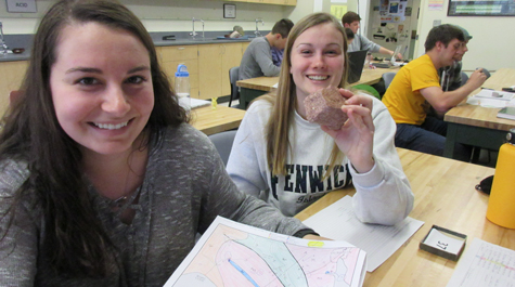
The students weren’t distracted from the real geology by the fake geography, either. At a lab session, tables of undergraduates got down to business mapping the geology of their Andrast traverse with nary a mention of what the orcs might be doing today. They were given 30 rock samples to examine, representing different points on their map.
The immediate task was to determine if the sample is a previously undiscovered type of rock, which would call for a new unit in the map. Madison Renshaw ’18 held up a sample labeled number 37 and declared it “a nice arkosic sandstone.” Her “geo bud,” lab partner Emily Mushlitz ’19, challenged that identification.
“It’s regular arkosic sandstone,” Mushlitz said.
“It’s nice!” Renshaw insisted.
“But,” Mushlitz said, “gneiss is a different kind of rock.”
The fall semester is under way and Bailey is making preparations for spring, when he’ll teach the second segment of the epic quest of the Structural Geology of Middle Earth. “We should not hop frivolously about the Shire,” he said. Bailey added that his plan is to move the class focus systematically into new terrain each year, until the geology of Middle Earth is comprehensively mapped.
“Last year we began our research on the great southwestern cape of Andrast,” he said. “We discovered old rocks — really old rocks, basins created as the Great Sea was birthed, and simmering volcanoes that, as best we could tell, might have served as Gollum’s refuge. We shall move to the east from our initial study into South Gondor and then up to the great heights at the edge of Mordor — Ephel Dúath, the Mountains of Shadow.”