
How will humans adapt to climate change? Ask a Viking
Fjord explorers:
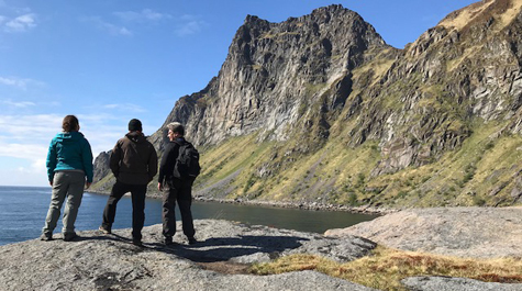
William & Mary geologist Nick Balascio is part of a team of climate scientists, archaeologists and students working to understand the impact of environmental change on Viking society. Leah Marshall ’19 (left), Balascio (center), and Stephen Wickler of Tromsø University survey a fjord inlet on the island of Vestvågøya.
Photo by Nick Balascio
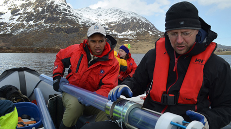
Coring lakes:
Moussa Dia ’18 and Billy D’Andrea of Columbia University prepare to collect a sediment core on Indrepollen, a Viking Age harbor location.
Photo by Keving Krajick
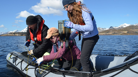
The haul:
Eve Pugsley ’18 recovers a sediment trap from Indrepollen.
Photo by Keving Krajick
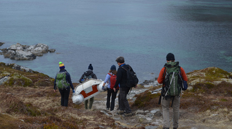
Lake bound:
Members of the research team carry a boat and coring equipment to a lake on the north side of the island Vestvågøy in Norway’s Lofoten Islands. From left to right: Lorelei Curtin of Columbia University, Moussa Dia '18, Eve Pugsley ’18, Stephen Wickler of Tromsø University and Nick Balascio.
Photo by Keving Krajick
William & Mary geologist Nick Balascio recently returned from Norway. He’s part of a team of climate scientists, archaeologists and students who are working to understand how environmental changes impacted Viking society during the Iron Age.
The research team, a collaboration among William & Mary, Columbia University, Tromsø University and the Lofotr Viking Museum, set its sights on the Lofoten Islands. The string of islands along the northern coast of Norway developed from small agricultural outposts to prominent Viking power centers during the Iron Age. The team plans to use biogeochemical markers left in lake sediment to chart environmental changes and reconstruct human activity patterns on the islands.
“In some of these coastal regions, you can see the Vikings were moving their harbors because of sea level change,” Balascio said. “Having access to a harbor was especially vital, because fishing was one of their main resources. If sea level change was affecting harbor access, the chieftains would have had to figure out a way to maintain trade and power.”
The Lofoten Islands are located above the Arctic Circle, which makes the region a particularly interesting case study for researching climate change, Balascio said. The Vikings were able to develop an agricultural settlement right at the edge of where agriculture was possible. The Vikings also relied on access to the ocean, as cod was one of their main trading commodities. Those two factors led Balascio to look for evidence of environmental fluctuations, because even the slightest change would have greatly affected Viking civilization.
“Right near the end of the Viking Age, we’re still trying to pinpoint the exact chronology, you see the abandonment of all these Viking boathouses,” Balascio said. “Likely they were relocating to another part of the coast, because the sea level was lowering.”
Unlike sea level rise, which climate scientists see as a major threat today, the Lofoten Islands were experiencing a relative drop in sea level. As glacial ice melted, its weight was lifted from the land, causing the Earth’s crust to rise. In fact, the land was rising so fast entire Viking chiefdoms were left without a way to access the ocean, Balascio explained. Ports became landlocked, because the harbor had literally risen out of the sea.
Due to the particular geology of the region, changes in climate caused the relative sea level to fall over the past 10,000 years, Balascio said. It’s not that the water was drying up, it’s that the land was heightened. Glaciers once made up a large amount of the arctic landmass. As they melted, the pressure removed from the Earth’s crust caused the land beneath it to rise.
Picture getting up from a mattress after lying down. The indentation left by your body will rise until the mattress gets back into its original form. Though much of the arctic ice melted long ago, the land it once covered is still rebounding from its ice-age burden. This ongoing adjustment of the Earth’s crust is called glacial isostatic adjustment.
“The land surface has been rebounding over the last few thousand years since the ice left,” Balascio said. “Most Viking Age boathouses are at least two meters above present sea level, because the sea level was actually falling. It’s not necessarily the same thing that’s happening today, but it is a clear example of how sea level change had an influence on a civilization.”
Balascio took his first research trip to Norway as a Ph.D. student in 2007. For the better part of the past decade, he has wanted to return and build on his early work there. Last year, he received funding from the National Science Foundation to go back to Norway. His current research is primarily focused on using biomarkers in lake sediments to chart environmental and societal changes during the Iron Age (c. 500 BC-AD 1100).
“A main objective is to test the hypothesis that climate variability and sea-level variations had an impact on patterns of human settlement,” he said.
The team began fieldwork last year, with two undergraduate geology students Moussa Dia ’18 and Eve Pugsley ’18 coming along to help collect samples. This summer, on a return trip, Leah Marshall ‘19 joined the field crew. The experience was hardly a vacation.
“We work on these little, inflatable rafts to collect lake sediment,” Balascio said. “It’s exciting, but it’s also really uncomfortable.”
Lofoten island lakes were created by glaciers, Balascio explained, which means they are extremely deep – anywhere from 60 to 150 feet. While they are lakes today, they were once harbors that led to out to the ocean. The sediment the lakes contain holds the key to understanding that transition. The field crew is responsible for coring the lakes, taking long tubes of sediment from the lake floor. The core tubes are lowered over the sides of inflatable rafts with ropes, filled with sediment and hoisted back up from the depths.
“That’s the most challenging thing, just working on lakes that are that deep,” Balascio said. “We have to recover the cores intact and we’re not on big vessels. We’re on these tiny rafts.”
Back in the lab at William & Mary, Balascio’s students Dia, Pugsley and Marshall have helped analyze the samples to try to piece together a historical record where one doesn’t exist. Much of what remains of Viking history was passed down through folklore, Balascio said, so his students are using geochemical analysis to try to build an environmental and archeological narrative.
“We’re analyzing sediments, trying to provide chronologic information and context through radiocarbon dating,” Balascio said. “When you go back in time, the records get more scarce. You are limited in the information you have, because there are no written records.”
The sediment analysis is still in its early stages and Balascio expects it to be at least another year before he has a clear picture of how the Vikings responded to climate change. Even at this nascent stage, Balascio says he is already starting to get a sense of how people lived in one of the harshest environments on Earth.
“It’s a good reminder that people have been responding to and adapting to climate change for a long time,” Balascio said. “It’s not something that’s necessarily new or happened in the last 150 years with global warming. This is something that civilizations have dealt with for a very long time.”