
The Banshees take to the field to rewrite the geological history of Virginia
Large swatches of North American maps might as well be labeled “Terra Incognita” or even “Here be Dragons,” as far as geologists are concerned.
“It’s because these maps were made before the plate tectonics revolution, and the advent of modern geochronology,” Chuck Bailey said. Bailey was speaking of Geologic Survey maps created by antediluvian, or at least pre-tectonic, geologists.
“Geologic maps,” Bailey explained, “are maps that illustrate what is underfoot everywhere in a particular area. The patterns they reveal tells us much about the geologic history of a region.”
Revised maps are required when the understanding of what is underfoot changes. A change in understanding like the 1960s-70s plate tectonics revolution could result in producing a map that’s completely different.
Bailey, a professor of geology and chair of the department, mentors a group of William & Mary student geologists who have been working to rewrite the geological history of a portion of central Virginia. He said the group’s findings are revealing aspects of the area’s geology in more detail than existing geological maps. It’s part of a larger effort by the U.S. Geological Survey to train undergraduates and use their data to refine geological knowledge.
“The U.S. is a big place,” Bailey added, “and much of the country has not been geologically mapped in any type of detail scale.”
The team members call themselves the BuckMarlSon Banshees, creating a portmanteau name from Buckingham, Albemarle and Nelson counties, which intersect at their area of interest. The Banshees will present their draft revisions at a July 29-30 field review near Howardsville, Virginia. It’s a necessary step in the process that leads to publication. Bailey expects a dozen or so professional geologists to attend, some of whom won’t hesitate to ask the Banshees tough questions.
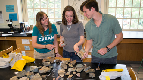
The core of the Banshees are Vinny Cunningham ’16, along with Ciara Mills and Anna Spears, two 2015 William & Mary graduates. Mills and Spears worked on the BuckMarlSon analysis for their senior honors theses and so the field review is a kind of capstone event.
The object of the Banshees’ investigation is officially known at the U.S. Geological Survey as the Howardsville 7.5’ Quadrangle. The USGS has funded the Banshees’ work and Doug Howard, the program director of the USGS Educational Mapping Program, is expected to be on hand at the field review.
The Banshees have been working on a quadrangle that is geologically quite interesting, as it sits astride the geological boundary where Virginia’s Piedmont meets the Blue Ridge.
The Piedmont-Blue Ridge border region is an important zone in eastern North America. The Banshees argue that, geologically speaking, it’s a spot where North America and Africa came together, millions upon millions of years ago. The evidence, they say, is written in stone.
“The rocks in the western Piedmont are less deformed than they are right at the boundary of the Blue Ridge,” Spears said. “You would expect this, but only after you understand the theory of tectonic plate movement.”
Mills explained that an ancient supercontinent called Rodinia split apart, depositing some of the rocks in the Banshees’ territory — formations now known as the Lynchburg Group and the Catoctin lava flows. The Earth’s plates kept moving, creating and tearing apart land forms and leaving telltale signs in the rocks
“We think there is a zone of highly deformed rocks in the quadrangle that is the fault zone where Laurentia and Gondwana came together to form Pangaea,” Mills said.
“And Laurentia now is the North American plate; Gondwana is the African plate,” Spears added.
The Banshees are building their case on bedrock — literally. The area is heavily forested: “I like to say than mapping out in central Virginia is a little like working in a jungle,” Mills said. Since there’s not much rock out in the woods, they look for outcrops in stream channels where rock has been exposed by water and erosion.
They work a portion of an area that was mapped at a less detailed scale in 1968 by a geologist named Ernest Ern. Like Ern, the Banshees found the bedrock to be mostly a rock known as phyllite.
“Some geologists have called this region a sea of phyllite. It’s a type of metamorphic rock, between a slate and a schist,” Cunningham said. Ern’s map shows immense brown areas, indicating phyllite bedrock. The Banshees have taken a closer look, revealing that the area isn’t as monolithic as Ern’s 1968 map shows. For one thing, they found areas that showed considerable variety even among their phyllite samples.
“The Piedmont, and the transition zone between the Blue Ridge and the Piedmont, is where you have these different phyllites,” Cunningham said. “Anna wrote a 50-page thesis on the different kinds of phyllites that you have in the western Piedmont.”
“These rocks are heavily deformed. And they’re more deformed at certain places,” Spears said. “Our questions went from did these plates move against each other to just how did they move against each other. And from what direction? What was the extent of the deformation?”
The Banshees have another way to track plate tectonics. By paying careful attention to the minerals found within the rocks, geologists can extrapolate the forces that made them. Plates sliding on top of each other generate tremendous friction, which in turn produces heat and pressure.
“When you get up to a certain temperature and pressure, different minerals will form,” Spears explained. “You can actually use those minerals as an index to tell you what temperature and pressure.”
The quadrangle contains a number of mines and quarries, most of which are defunct. Soapstone, used for talc and ornamental items, is one product. The Banshees ran across many Civil War-era manganese oxide quarries.
As the field review approaches, the Banshees are compiling their digital map, going over their field notes and sorting and labeling the kilos upon kilos of rock samples hauled out of their quadrangle. They’re preparing answers for questions they expect the professional geologists to ask. Spears says they’re expecting the discussion to focus on one major question: What is geologic nature of the Piedmont/Blue Ridge boundary? In layman’s terms: Where does the Piedmont stop and the Blue Ridge start?
“It’s definitely very fuzzy,” Mills said. “It’s not a line — rather it’s a five-kilometer-wide fault zone”
Some geologists believe that the Piedmont contains “exotic” rocks left behind by the African plate.
“If that’s the case, then we say this is where the exotic rocks stop and where the Laurentian rocks start,” Spears explained. “I think it may be impossible to say that, because the rocks are folded into each other.”
Once the Piedmont-Blue Ridge seam is definitively mapped, the Banshees offer a suggestion for a name: the BuckMarlSon Transition Zone.
“That would be awesome,” they agreed.