
The Process of Archaeology
First Steps
 Currently, only a small part of the archaeology in this country is done through independent research at universities. In fact, almost eighty percent of professional archaeologists work outside academia. Most of their research stems from archaeology related to construction projects. Under a process called cultural resource management, construction planners consider a project’s impact on the nation’s heritage, along with environmental issues and landowner concerns. Any construction using federal funds must either avoid or investigate significant historic and archaeological sites.
Long before road or bridge building begins, archaeologists assess the likelihood of finding archaeological sites in the project area. This preliminary research involves reviewing archaeological site records and reports relevant to the area, kept by the Department of Historic Resources in Richmond. Historic maps and more general archaeological studies are also consulted to find out how the area was settled and used in the past, and therefore the kinds of sites to expect. If modern activity or natural agents like erosion have not compromised sites within the proposed construction limits, archaeologists carry their research into the field and perform a sytematic survey to locate sites.
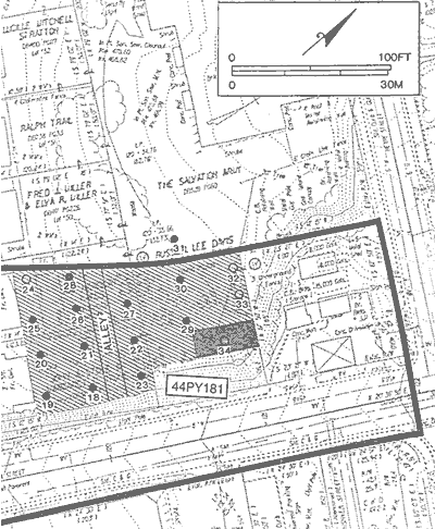
Photo: A segment of construction plans for the Main Street Bridge improvement shows the results of archaeological survey. The thick dark line defines the limits of construction impacts that were expected for the bridge improvement. The grid of circles in the shaded area represents systematic shovel testing in an area with high probability for finding archaeological sites. It is relatively level and has no sign of recent disturbance from modern construction. Indeed, most of the shovel tests are darkened, indicating they were positive (contained artifacts). The archaeologists designated this cluster of positive tests Site 44PY181 and recommended it as potentially significant. Later, more intensive testing confirmed it significant enough to be eligible for listing on the National Register of Historic Places. Since it was impractical for VDOT to avoid the site during construction, 44PY181 underwent the large-scale 'data recovery' excavations described on this website. (from Wuellner et al. 1993:Fig. 14)