
Finding and Defining Sites: Survey
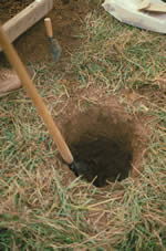 The goal of survey is to locate archaeological sites within the construction project area and decide if they might be significant. In drier regions or in plowed agricultural fields, sites can be found by methodically crisscrossing an area and looking for artifacts on the ground surface. For surveys in Virginia, this practice is more the exception than the rule. Often the ground is covered with vegetation, so the only solution is to sample the area by digging a systematic grid of small holes called shovel tests. The typical shovel test is about the diameter of a dinner plate and generally no more than knee-deep. All soil from the test is sifted through quarter-inch wire mesh to recover artifacts. The kinds of artifacts in each test are recorded, along with a description of the stratigraphy (layers of soil) exposed in the pit wall.
Archaeological sites are delineated by clusters of positive shovel tests (containing artifacts) and other factors like topography. Once sites have been located, the archaeolists must decide if they might be significant. Historic preservation laws define sites as significant if they meet the requirements for listing on the National Register of Historic Places. The most basic requirement is “integrity.” Archaeological soil deposits must be relatively free from disturbance like modern construction or deep plowing. Further excavation is only worthwhile if at least some areas of the site retain the artifacts and features in the same place as when the site was abandoned. Once the integrity benchmark has been satisfield, a site must also be likely to yield important information about a time period and research topic that is of interest to other archaeologists. If a site appears to meet these significance benchmarks and cannot be avoided by construction, it undergoes more intensive testing called “evaluation.”