
Early History
Following centuries of occupation by native groups, Douglas Point was settled by English planters by 1653 or earlier.
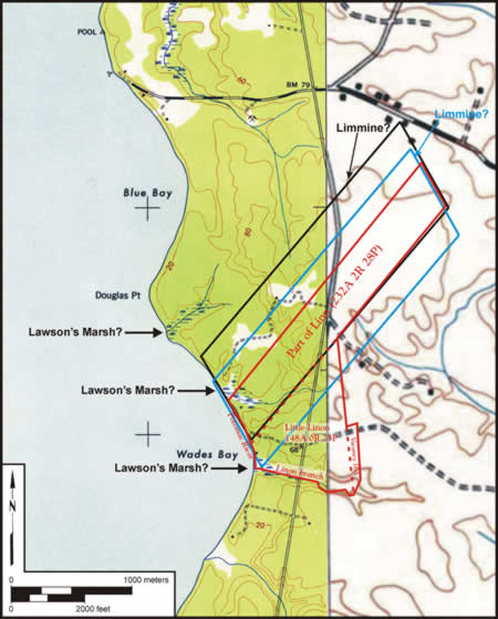 In 1653 a tract of land fronting the Potomac river was patented by a man named John Lawson. The patent stipulated a tract called "Limmine" some "four leagues above Nanjemoy". During this period this particular area was newly settled by English colonists and was in Zachia Manor, the predecessor to Charles County. Meaning threshold in Latin, "Limmine" may reflect the patent's "frontier-like setting" at the edge of early European settlement in this part of Maryland.
The patent remained in Lawson's hands until 1678, when Zacharia Wade (Wade's Bay) noted himself as living at "Limme". Wade had accumulated well over 3,000 acres in the area which he distributed to his son, Robert, and daughter, Theodosia, in 1727.
Zacharia Wade took ownership of "Linns" and an adjacent tract called "Linns Enlargement" around this time, and inherited a sizeable amount of cash and tobacco. The Wade family continued to own Limmine until the 1750s. John Semple, a merchant, purchased the tract, 100 acres, for 3,000 pounds of "crop" tobacco and 20 shillings in1755. The original 1653 tract had been subdivided and included into neighboring parcels but was largely recombined by future Maryland governor John Hoskins Stone. Descended from William Stone, the Loyalist fighter of the 1655 Battle of Severn, he was also the brother of Thomas Stone who signed the Declaration of Independence.
Stone kept the tracts until 1790, when he traded with Capt. Francis Shepard for Middle Green Enlarged, a nearby plantation in the same Durham Parish. Shepard and Stone had served together during the Revolutionary War and likely developed a lasting relationship that led to this land swap. Capt. Shepard's family had lived in the area for at least several decades time, and so he may have been interested in the Linns tract for some time.
 Francis Shepard was listed as heading a household of three males over the age of 16 and three females over 16 as well. Seven enslaved African Americans were also listed, more than double the labor pool of his father John Shepard. However, by 1810 Francis Shepard was only listed as owning four slaves, which may reflect a belated inheritance recoup by his brother, Thomas.
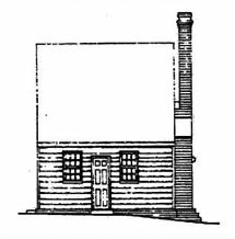
The tax assessment of 1798 lists a house, valued at $150, on a 2- acre lot contained within the Shepard parcel. This is consistent with the hall and parlor style of house that was the oldest portion of the Chiles home. However, the house would have then been known as Mount Pleasant, perhaps for its position on the edge of the bluff, overlooking the fields below that stretched out to the banks of the Potomac.
After Francis Shepard's death the family maintained Mount Pleasant, eventually executing and settling his will in 1841.