Close menu William & Mary

Batten School of Coastal & Marine Sciences & VIMS

Vision for a Resilient Future

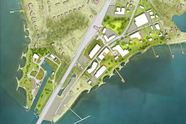
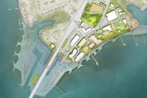
William & Mary's Batten School of Coastal & Marine Sciences & Virginia Institute of Marine Science (VIMS), located on a 42-acre campus in Gloucester Point, Virginia, is one of the largest marine science centers in the U.S. This comprehensive plan outlines a strategic roadmap to guide future campus development and resilience efforts in the context of climate change. The plan's goal is to create a resilient future for the Batten School while maintaining and enhancing its academic and research potential.

The consulting team utilized existing conditions information as well as state and federal climate impact projections to create a set of planning scenarios that are specific to the Batten School & VIMS. The resulting plans integrate knowledge gathered from individuals, documented plans, observations and climate projections.

Key Challenges & Planning Principles 

The campus is divided into two areas by Highway 17: the Upper Campus and the Boat Basin. The site's topography creates three elevation zones: high ground (30-34 feet), mid ground (10-30 feet), and low ground (0-10 feet). This topography, combined with the risks of coastal storms like hurricanes, tropical storms and Nor'easters, as well as sea-level rise, presents significant challenges for the campus.

The plan is guided by overarching principles that emphasize history, landscape and sustainability. A key part of the planning effort is to integrate green infrastructure, such as bioswales and permeable surfaces, to manage stormwater runoff and improve campus resilience. The plan also seeks to leverage the landscape, recognize the university's past and place and commit to a sustainable future. 

The Next 75 Years

While the Batten School & VIMS faces water-related challenges, future campus development presents many opportunities. The plan provides a high-level framework for campus planning, focusing on long-term impacts of sea level rise through scenarios for 2040, 2060 and 2100. The following conceptual images denote the potential and expected sea level rise impacts to the Gloucester Point campus.

Topographic map of the Gloucester Point campus in 2025.

Campus 2025

The current campus layout is challenged by steep terrain, which limits public space and waterfront access and makes it difficult to create ADA-compliant routes. The previous VIMS Master Plan (2011) and the Visitor Experience Conceptual Design Studies (2023) require a renewed long-term vision to address the growing impacts of climate change and sea-level rise.

Projected map of the Gloucester Point campus in 2040 showing topographic changes after sea level rise impacts.

Campus 2040

In 15 years, by 2040, there will be no buildings or key campus connections at risk at the Batten School. Most of the living shorelines and attached water outfall infrastructures will need to be increased in height, or will otherwise be underwater. Construction is planned for a new Fisheries Science Building, a Marine Operations Administration Complex and a Riverwalk. Between 2025 and 2040, Boat Basin Campus will lose 1.32 acres of upper land and living shoreline and Upper Campus will lose 0.79 acres of upper land and living shoreline.

Projected map of the Gloucester Point campus in 2100 showing topographic changes after sea level rise impacts.

Campus 2100

In 75 years, by 2100, the current Boat Basin Campus at the Batten School will be mostly underwater. Additional parcel acquisitions are recommended near campus peripherals. At the Upper Campus, current ABC Field House, Acuff Center parking area and 1964 Floodwall will be under water during high tides. Concrete Pier Pump House and related sea water lines will likely be underwater during high tides or storm events. Additional land acquisitions are recommended to maintain operations and research needs. Between 2060 and 2100, Boat Basin Campus will lose 9.8 acres, most of the campus upper land, to intertidal zone and Upper Campus will lose 1.48 acres of upper land to intertidal zone.

Read the Campus Comprehensive Plan

If you experience any difficulty accessing the information due to a disability, please contact us at [[campusplan]] for assistance. The following is provided in PDF format.