August 14, 2002
By the time we left the site yesterday there were almost no doubts that the property has genuine archaeological potential. At the end of this week we will have ample documentation of the prospects for these lots to contribute useful information. The greater part of the historical evidence is related to Native American Indian occupation (10,000 BC – AD 1610), and diverse activities during the 19th century (1825 – 1890).
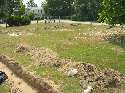
Our hand excavations in 1 x 1-meter test units are ongoing. These squares give us important controlled samples of artifacts from representative sections of the property. Our goal is to complete at least seven such units. The newest one will be placed in the southeastern quadrant of the lot where impressive Indian artifacts are showing up.
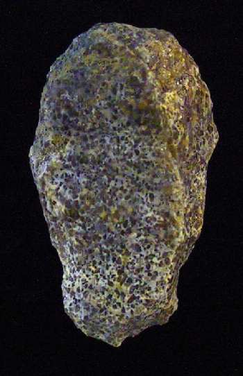 Some particularly interesting artifacts have come out of the six test units opened so far. The oldest artifact found by the project is a distinctive type of stone “endscraper.” It was used by prehistoric Indian inhabitants as early as 12,000 years ago, at the close of the last Ice Age! Such stone blades were attached to handles to create a scraping tool for cleaning animal skins. Of added interest is the fact the stone from which it is made – oolitic quartzite – comes from far away, either in northeastern North Carolina or near the border of West Virginia and Maryland.
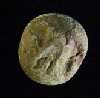 We finally recovered a Civil War military-issue artifact – a standard "eagle button" worn on a jacket or overcoat. Probably much of the other debris on the site was deposited during the war, but it looks more like domestic refuse than military discards. The reason, of course, is that City Point was functioning as a supply, processing, and medical center rather than a battlefield.
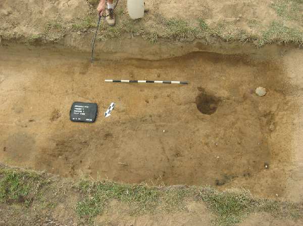
Yesterday the city provided a backhoe and operator to remove sections of the topsoil. The purpose of this limited stripping was to search for "features" and other intact deposits. As described before, the locations of buildings and special activity areas can be determined by stains in the soil – the things that we call features. Just a small portion of the property was stripped of topsoil (going was slow due to the hard dry soil) but the results are informative.
 The first trench revealed the location of the house that once stood on the property. Although this structure is reported to have been built about 1840, much of the evidence we found was recent because the house was occupied until at least the 1980s. Knowing the precise location of the building is useful, however, in planning future work and for interpreting what is found around it.
The second trench exposed a large, rectangular feature and several post holes. The large feature is oriented diagonally to the street grid and at present the purpose of this trash-filled pit is unknown. Artifacts observed at the top of it appear to date from before the Civil War. One preliminary suggestion is that it marks the location of a small outbuilding on the property, perhaps even a privy or “outhouse.” Another possibility is that it does relate to Civil War activity. An 1865 drawing of City Point indicates three small buildings at approximately the same location. These are labeled on the map as “Stor.”– storage buildings perhaps? Excavation of this pit feature will begin this afternoon after it is carefully recorded in plan.
A good sense of the archaeology on this vacant property is emerging. By Friday afternoon a representative sample of artifacts will be available for study, where artifacts are concentrated will be established, and the presence of intact deposits will be confirmed. A tentative recommendation would be to invest the remainder of the available time on similar exploration of another city-owned property. Such a strategy will provide the broadest basis for planning future studies.