
Mapping recovery

Students aid on-the-ground relief efforts in Nepal from thousands of miles away
A 7.8 magnitude earthquake rocks a country thousands of miles away. The death toll is horrific. Significant numbers of people are reported missing. On-ground infrastructure is decimated.
This story was updated May 5, 2015. - Ed.
People across the globe watched with little idea of how to help Nepal after Saturday's quake, but William & Mary junior Lu Sevier knew immediately that there was something she, and her fellow W&M students, could do – crowd-source mapping.
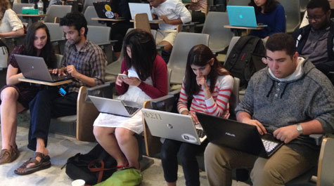
“We decided this would be a good way to help out with the relief effort,” said Sevier '16, who organized an April 27 work session in Millington Hall.
Crowd-source or collaborative mapping leverages people power to digitize mass amounts of aerial imagery. Sevier coordinated the effort through Humanitarian OpenStreetMap (OSM), an organization – according to its website – that facilitates collaborative mapping online.
Though not a Nepalese national, Sevier said she felt a strong need to help.
“This is a tangible way for college students to help out right away,” she said.
Sevier, a biology major, and her team used word of mouth and social media to promote the work session. She said she was surprised and pleased by the turn out.
“I was excited that students supported this event, especially at such a busy time in the semester,” she said, referring to the end of classes and the start of final exams. “We had 25 or 30 students attend and I’ve had others asking me about other work sessions.”
Some of those involved where even from the impacted country.
Prabesh Basnet ’15 was born in Nepal and still has family there. He said, thankfully, his family members are safe and accounted for. But given the chaos and assistance required on the ground following the quake, he wanted to find a way to help.
 Through her work as a student manager with William & Mary’s AidData project, Sevier has previous experience using and teaching geocoding software. She learned about OpenStreetMap through AidData’s work with USAID and its GEO Center. She participated in a similar project last summer in Washington, D.C., working with the Red Cross to map areas in Africa impacted by the Ebola crisis.
“Wanting to help from so far away and having backgrounds in development, data and geographic information systems, we came together to assist the Humanitarian OpenStreetMap Team (HOT),” Basnet said.
The data they inputted is already in use.
“The data being produced by our students is already informing relief efforts," said Dan Runfola, geospatial scientist at AidData and research assistant professor at the university. “The details students are able to identify in satellite images – where a road used to be, where buildings once stood – is helping organizations like Save the Children direct their decision making on the ground in Nepal. It is still too early to know what impacts our contributions might have, but the feedback we have received from the frontline relief efforts is ‘keep it coming.’”
AidData is helping to coordinate the data generated by W&M's crowd-sourcing effort.
Sevier added that AidData is also using the data to create a Nepal information map. The map combines Tomnod satellite crowd-sourced data, Youtube reports, news reports and OSM with nightly updates.
Their initial effort was so successful that a second work session was held April 30 at William & Mary's Institute for the Theory and Practice of International Relations where another 30 - 35 students participated.
“W&M has definitely proven to be a home for data-driven student engagement and I hope to see more such successful efforts in the future, for Nepal and beyond,” Basnet added.
Sevier said prior experience isn’t necessary to begin helping out; participation just requires a little training. The process is quick, she noted, saying it generally takes just 15-20 minutes to get someone trained to use the OSM software.
“Once you are trained, it’s a very independent thing,” added Sevier. “You can do it anywhere.”
Mapping projects or tasks are publicly listed on the OpenStreetMap site. Projects are broken down into grids. Each contributor takes on one specific grid at a time. Sevier said it generally takes no more than one hour – and more often less than that – for an individual to trace the roadways or note the buildings within a given grid. The completed projects get returned directly into HOT which verifies the submitted data and then makes it available to first responders, aid workers and government agencies.
Moving forward, Sevier hopes to broaden her crowd-sourcing efforts.
“I’m really passionate about international development and GIS,” she said. “I was prototyping [with the Monday event], I think this could be done on a large scale.”
Sevier noted that there are likely to be long-term mapping needs related to the Nepalese earthquake.
“There are still project requests coming through OpenStreetMap related to the Pam cyclone in the Vanuatu Archipelago and Ebola outbreaks in Sierra Leone and Guinea,” she said.
Sevier was scheduled to teach GIS this summer at Katmandu University in Nepal. Those plans are up-in-the-air at the moment, but she hopes to continue her work somewhere.
“[Crowd-sourcing] isn’t something people immediately think of in a time of crisis, but this is something we can train students to do and then they are trained and ready to go,” she said. “We can make a huge difference.”