
Lake cores may solve mystery of Easter Island civilization
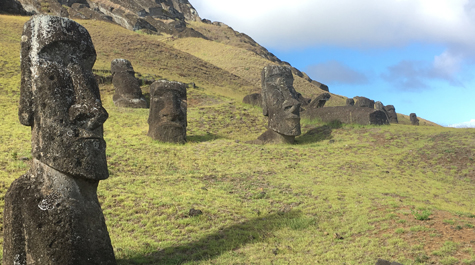

The Rapa Nui people of Easter Island are best known for carving hundreds of giant heads out of volcanic rock. For paleoclimatologists like Nick Balascio, the Rapa Nui are known for something else entirely. They have been used as a case study for how poor environmental stewardship can lead to societal collapse.
A remote outpost in the South Pacific Ocean, Easter Island is located some 2,300 miles west of South America and 2,600 miles east of Tahiti. When Polynesian explorers first arrived between 800 and 1200 AD, the island landscape was lush with palm forests. The prevailing theory holds that settlers’ slash-and-burn farming practices led to extreme deforestation, explained Balascio, an assistant professor of geology at William & Mary.
The result of such deforestation has been referred to as “ecocide,” social upheaval and dramatic population decline as a result of rapid ecological change, Balascio said. When Dutch explorer Jacob Roggeveen arrived on the island in 1722 AD, he described a sparsely populated territory “destitute of large trees.” However, more recent work has shown that this prevailing theory may not entirely be true.
Balascio hopes the key to understanding the rise and fall of the Rapa Nui people rests in sediment he recently collected from Easter Island’s biggest lakes. He and a team of scientists plan to use the sediment records to chart the island’s environmental history over the past 4,000 years.
“There’s holes in the existing data that have been used to tell this story,” Balascio said. “We’re trying to address those holes.”
Balascio explained there are three main questions driving his research: When did people first arrive on the island? What is the long-term climate variability of the island? And what evidence exists for widespread burning on the landscape? By working to solve those three questions, he hopes to gain a broader understanding of how humans can affect their habitat and how past civilizations were influenced by environmental changes.
“This civilization developed to a point where they could create these giant statues and then became pretty withered away,” Balascio said.
In order to tell the full story, Balascio realized he needed to pair geology with archeology. The sediment cores provide precise chronological information about the island’s climate. To see how environmental stressors (like overexploitation of resources) may have influenced society, Balascio had to overlay his climate data onto records of what the civilization left behind.
“We started working with archeologists, trying to use these tools of what lakes can provide — their continuous sediment records — to augment the archeological data,” Balascio said. “With the overall objective being to better understand human-environment interactions on Easter Island.”
The field team was comprised of climate scientists and archeologists alike. Balascio and his senior thesis student James Van Hook joined William D’Andrea, associate research professor at Columbia University’s Lamont-Doherty Earth Observatory, and his Ph.D. student Lorelei Curtin, Raymond Bradley, director of the Climate System Research Center at UMass Amherst, and Chilean archeologist Andrea Seelenfreund.
Funding for the fieldwork came from William & Mary’s Reves Center for International Studies, the Center for Climate and Life at Columbia University, the Vetlesen Foundation and the Explorers Club of New York.
While Balascio, D’Andrea and Bradley have worked together for years, their research has been primarily conducted in arctic climates, working to track environmental change over thousands of years. The recent trip to Easter Island was the trio’s first foray into the South Pacific. For Van Hook, it was his first time out of the country.
“Talk about a great first use of a passport,” Balascio said.
Just getting to Easter Island required nine months of legwork. The team had to secure permits to conduct fieldwork on the island. They had to seek special approval from the local Rapa Nui council and the Chilean Council of National Monuments to collect samples from culturally significant locations on the island. Balascio had to receive a soil permit from the U.S. Department of Agriculture for transporting the samples into the U.S. and storing them in his lab.
“We have a lot of research experience using lake sediments as archives of past environmental change,” Balascio said, “but this trip was different from other climates we’ve worked in. In the past we were in the arctic, coring lakes and trying to reconstruct how big glaciers were over time. While this was our first experience in the South Pacific, we have been applying these same techniques for years.”
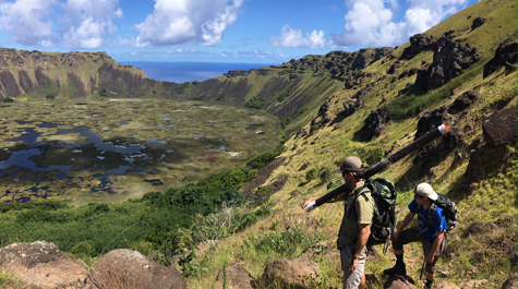
The primary target for their coring techniques was Lake Raraku. The lake is an ideal place to core because it contains a continuous sedimentation record of the past 4,000 years. It’s also the site where stone for the island’s iconic statues was quarried.
“There was only one quarry on the island that was used to make these things,” Balascio said. “If you think of the island like a small triangle – it’s only about 14 miles across – then picture these statues being moved all over that area. You find them everywhere.”
Lake Raraku is significant from both a geological and archeological standpoint, Balascio explained. He believes the lake’s sediment holds evidence of the dawn of quarrying activity, a key moment in the history of the Rapa Nui civilization.
“It tells us about a time when people came together,” Balascio said. “There were these different groups, who lived on different parts of the island, but at some point they had to come together because they were all working out of the same quarry.”
The lake was also an important source of fresh water for the Rapa Nui, which meant it served as a gathering place as well. The research team plans to extract DNA preserved in the sediment and sequence it to target markers for rat and chicken, the principal food source brought by Polynesian explorers. Balascio hopes the DNA will help date the arrival of the island’s first settlers.
The team will also be analyzing the sediment for molecular biomarkers that relate to burning, certain organic compounds that get produced by burning wood and carbon. They hope to be able to find what they call “the deforestation signal,” evidence from when the island’s greatest natural resources ran out.
“When a resource was overconsumed, it led to social strife,” Balascio said. “All that evidence gets washed into these lakes.”