
Vision Plan
These guidelines propose the unification of the campus environment by the simplification and consistent design of the landscape and the sensitive insertion of new structures that mediate between the existing architectural expressions. The overall concept is expressed as a "Vision Plan." Architecture and landscape each have a role in the realization of this concept.
The Vision Plan reflects the following objectives for the campus:
The campus architectural and landscape character should be unified.
- The architectural configuration and character of the Old Campus should be preserved.
- New public spaces on campus should be created and connected by clearly articulated pedestrian circulation paths. New buildings should create and frame new public spaces wherever possible.
- Existing barriers to unifying the campus, such as roads and parking, should be removed (or at least minimized) wherever possible.
- The unique naturalistic attributes of the Ravine intervening within the campus landscape should be preserved and enhanced.
 |
 |
 |
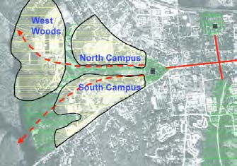
This plan envisions a unified campus image and character based on the historic expression of the Old Campus and the Sunken Garden Quadrangle, formulated on a new framework of clearly organized pedestrian pathways and public spaces. The disparate images portrayed by multiple existing campus precincts will be consolidated into a seamless transition between three newly defined campus landforms: North Campus, South Campus, and West Woods.
North Campus consists of the area north of the Sunken Garden and Ravine, and stretches from the Wren Building to the north-south branch of the Dell between Cary Field and the Yates Hall/Fraternity Complex area. South Campus consists of the area south of the Sunken Garden and Ravine; it encompasses the area from the Wren Building to Lake Matoaka in the west. West Woods consists of the area north and west of the Dell, with Lake Matoaka to the west. The Old Campus will merge with the North and South Campuses as the barriers between the Old Campus and the rest of the North and South Campuses to the west are eliminated.
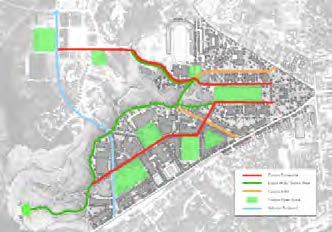
The diagrammatic campus plan in the figure illustrates the first step in the reunification of the campus. The figure illustrates two objectives: First, a hierarchy of pedestrian paths is defined, with the primary promenades originating north and south of the Sunken Garden, and extending west through the North Campus and South Campus, respectively. Second, new civic spaces are defined along these routes. The southern promenade passes the Barksdale recreational field, connects directly to the quadrangle formed by Swem Library and Andrews Hall, and terminates at the Lake Matoaka amphitheater. The northern promenade extends from the Sunken Garden, leads to a new plaza at University Center, continues to a public space at Yates Hall in the residential district, and terminates at public spaces to the east and west of William & Mary Hall. Finally, the barriers imposed by roads and parking are reduced with the conversion of Landrum Drive and Blair Road to pedestrian paths.
By establishing a circulation framework that links memorable public spaces, the campus' unique geography becomes a more understandable composition. In addition, transforming Landrum Drive to a pedestrian path allows the South Campus to blend into a single entity.
From this circulation framework, the hierarchy of the campus can be described as follows:
Pedestrian Circulation
The landscape elements of the two primary pedestrian promenades will define these paths as being the most important routes on campus. Other paths will be treated differently to communicate their secondary status.
Vehicular Circulation
Vehicular circulation within the campus will be located at the western perimeter of the campus. Vehicular access into the core campus will be limited to service and emergency vehicles, with short-term parking and drop-off at specific locations. On-campus parking will be consolidated at three locations on the campus periphery.
Campus Public Spaces
The primary public spaces on campus are located along the primary pedestrian promenades. These spaces include large public plazas, recreational fields and quieter academic quadrangles.
Building Addresses
All buildings located along the primary pedestrian promenades will "front" the routes. Service access will be available only at the side or rear entrances.
Edge Conditions
Buildings located adjacent to the primary campus civic spaces or along the campus boundary along Jamestown Road will contribute, in their configuration, to the definition of these edges.