
GIS Meets Mercury: Tracking the Fates of Toxic Chemical Release
 During the spring 2010 semester, ENSP 204 and GEOL 204 students completed a class research project examining the environmental factors that contribute to mercury contamination in the South River watershed. The South River flows through Augusta and Rockingham counties as well as the city of Waynesboro near the Shenandoah National Park in Virginia. The mercury released during the 1930s and 1940s from a DuPont factory in Waynesboro remains a problem. Since the mercury was discharged into the water, contamination of the South River is obvious. Interestingly, investigators have determined that adjacent lands downstream of the factory are also contaminated with mercury.
The mechanisms that allow for the migration of mercury from the aquatic environment into the adjacent terrestrial environment and subsequent return of the mercury to the aquatic environment are not well understood. Despite it being 50 years since the last release of new mercury, high mercury levels are still found in the soil, sediment, fish, birds and insects in and around the South River. GIS students examined the environmental conditions of the South River floodplain in an attempt to explain the environmental factors contributing to the retention and recycling of mercury in this region.
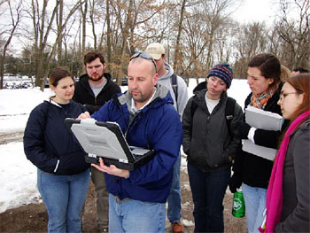
 Under the tutelage of Biology & ENSP faculty member Dr. Dan Cristol, W&M students visited the region in February to view the South River, the former DuPont factory, and myriad sample stations along the river. Over the past five years, Cristol and his students have uncovered evidence that aquatic mercury, once thought to be a problem only for fish and aquatic organisms, has migrated across the floodplain and is harming birds.
Working with data collected by consulting firm URS, the Department of Environmental Quality, and Masters students and undergraduates from William and Mary, students developed GIS projects in the new Center for Geospatial Analysis that addressed questions related to variation in mercury concentration across the South River floodplain. Students interpolated sample data to identify mercury hotspots and examined landuse, landcover, flooding, erosion rates, river channel characteristics and other environmental attributes in an attempt to find the conditions that contribute to the ongoing mercury contamination. Students also examined the environmental conditions that appear conducive to converting elemental mercury into the more hazardous methyl mercury, which readily moves up the food chain and poisons animals. Funding for the work was provided by the W&M Mercury Global Inquiry Group; selected projects appeared at the Reves Center’s International Mercury Expo in April 2010.