
Need to navigate W&M? We've got a map for that
Campus map
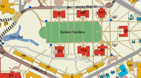
The new color-coded campus map is both easier for users to read and easier for campus officials to update.
Campus map
The new campus map is both easier for users to read and easier for campus officials to update.
But finding buildings -- and finding a wealth of information about them -- shouldn't be a problem anymore, thanks to William & Mary's new campus map. The color-coded map will be easier to keep updated, and it will eventually become interactive, including information layers on everything from campus services to environmental sites.
"The map is more than a convenience; it's a critical tool for advertising, information and planning," said Wayne Boy, director of Planning, Design and Construction for Facilities Management. "It will convey to anyone who utilizes it that the College is serious about state of the art communications which place the needs and convenience of users first."
In addition to the new campus map, the College community has another online tool that should enable them to better enjoy William & Mary's beautiful landscape. Earlier this month, the Department of Biology posted a Website tour of exotic trees and woody plants on campus. The site includes campus lore along with stories behind many of treasured trees on campus and how they function as a living library for faculty and student research.
The new campus map was funded by the College's Office of Publications and created by the Center for Geospatial Analysis.
Earlier this year, Cindy Baker, director of publications, gathered suggestions for the new map from faculty and staff members across the campus. She then began working with Boy; Dick Phillips, senior civil/structural review engineer; Stuart Hamilton, director of the Center for Geospatial Analysis; Ted Lyman, GIS coordinator for the City of Williamsburg; and Joel Pattison, Web designer and project manager, to figure out what could be accomplished. Jim Golden, vice president of the Office of Strategic Initiatives, strongly supported the project and authorized the publications office to fund the map.
"This was a pretty comprehensive campus endeavor," said Baker.
Hamilton hired several students to plot the campus over the summer with guidance from Lyman. Using GIS (a computer mapping program), they created a new, core map of the school. That core map is what is now available to users.
Over the next year or so, the group hopes to add information layers to the map. The layers available to the public will include information on Americans with Disabilities Act accommodations, security, campus services and campus events. Some controlled access layers will also be added to the map. These layers will contain campus utility, environmental and cultural information.
Baker said that the new map is more on par with what other Virginia state schools offer. The old campus map included sketches of buildings and campus features and was therefore very hard to keep current.
"The biggest benefit (of the new map) is that this can be updated incredibly easily," Baker said.
For instance, when a footprint for the new career center is created, it will be very easy to add that to the map using GIS. With the old map, an artist would have to create a sketch of the building and re-sketch the area of the map where it would appear.
When the map becomes interactive, its capabilities will surpass the maps of many of William & Mary's peer schools, said Boy. In addition to it being very easy to update, it will also allow users to customize the map according to their needs by selecting which layers are displayed.
"From the facilities side alone, this map and its layers represent a quantum leap in our ability to archive facility and utility data to aid planning, design, construction and maintenance," said Boy. "It will take us two years to get all layers in place and a firm commitment to maintain the map once established but it will more than worth the cost! This is tool we desperately need. We're extremely pleased to be part of the team on this project."
The new core map is available for download at www.wm.edu/campusmap. All of the interactive features are expected to be added to the map by the end of fiscal year 2010.