
Watershed Primer
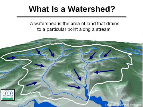
What is a watershed? A recent survey of residents in Williamsburg/James City County indicated that a majority of people do not know the definition of a watershed. Basically, a watershed is a section of land that drains to a common location, i.e., a catch basin or drainage basin. It is all the land surrounding a body of water that-when it rains-drains to that body of water. Land typically is located above the level of the water in streams and lakes, so naturally water flows downhill and collects in those streams and lakes.
The watershed typically is named for the body of water for which it serves as the drainage basin. The College Creek watershed, for example, covers 13.7 square miles of land in Williamsburg/James City County. The Chesapeake Bay watershed covers some 63,000 square miles of land from North Carolina up into portions of New York state.
The College Creek watershed "sheds" water to College Creek. In turn, College Creek drains into the James River. Thus, College Creek has its own watershed, but that watershed area is also part of the watershed for the larger James River watershed. In turn, the James River flows into Chesapeake Bay, so the College Creek watershed is also part of the huge Chesapeake Bay watershed. In fact, the Chesapeake Bay watershed is made up of thousands of small watersheds like College Creek that collectively provide the freshwater that runs into the Bay. The water and the materials carried by College Creek contribute to the water quality of the James River and, ultimately, Chesapeake Bay.
So how does the water get out of the watershed? When it rains, water can infiltrate into the soil and be carried downhill underground, to emerge eventually in streams and lakes. Some water, however, flows over the land surface and enters streams and lakes as surface water. For developed watersheds like the College Creek watershed, much of the stormwater does not infiltrate into the soil because it lands on roads, buildings, parking lots, sidewalks and open fields and lawns without extensive vegetation cover. Instead, this water typically flows into storm drains that pipe the water rapidly to local streams and lakes.
The surge of water flowing off of developed watersheds during storms carries with it sediments and dissolved contaminants that otherwise would not be transported to local waterways if the land was not developed. During storms, different types of developed land transport different amounts of sediment and contaminants to local waterways. For example, runoff from agricultural land tends to be higher in sediment and nutrients, whereas runoff from industrial land tends to be higher in greases, oils and heavy metals.
Responsible land development and advanced stormwater management practices can minimize the impact of these surges of water, sediment and contaminants during storms. Still, the water draining the watershed retains certain characteristics that collectively contribute to "water quality". Not surprisingly, watershed quality imparts water quality, i.e., the quality of water draining the watershed is a function of surrounding land use. We can use water quality to assess how land use influences our streams and lakes.