


New online tool helps better serve environmental justice
 The Elizabeth River Project (ERP) has teamed with researchers from the Virginia Institute of Marine Science and William & Mary to build an online mapping tool that can help the non-profit and other community partners better incorporate environmental justice issues into planning and restoration efforts. Collaborating with the researchers was an Environmental Justice and Equity subcommittee recently convened by ERP to develop its next Watershed Action Plan.
Joe Rieger, ERP’s Deputy Director for Restoration, says the US Environmental Protection Agency defines environmental justice or “EJ” as the fair treatment and meaningful involvement of all people with respect to the development, implementation, and enforcement of environmental laws, regulations, and policies. He says the new Elizabeth River Environmental Justice Tool “provides a great additional way for us to more deliberately focus our planning efforts in historically under-resourced communities of color.”
ERP is a local environmental non-profit that works to restore the Elizabeth River to the highest practical level of environmental quality through government, business, and community partnerships. The Elizabeth River is a three-branched Chesapeake Bay tributary largely within the cities of Norfolk, Portsmouth, Chesapeake, and Virginia Beach. Long infamous for centuries of urban pollution, it is now on the road to recovery through decades of collaborative effort.
“We’ve always worked with diverse communities with a commitment to EJ,” explains Rieger, citing as examples ERP’s Dominion Energy Learning Barge, which offers free hands-on environmental education for traditionally underserved students and a pilot effort to help Norfolk’s historically African American Chesterfield Heights neighborhood gain greater resiliency to coastal flooding.
“But,” he adds, “a current national renaissance for environmental justice has given us new hope that the community will be behind us in heightened efforts to identify and address environmental injustices as a top priority.”
ERP’s focus on environmental justice builds on a 2020 commitment by its Board of Directors to more proactively address racial disparities, and found a springboard with the group’s recent decision to update their community-based plan for Elizabeth River restoration. “The formation of our 170-member Watershed Action Team 2021 allowed us to devote additional resources and marshal greater support for a more deliberate focus on EJ topics,” says Rieger.
Dr. Rajni Shankar-Brown, a Professor and the Jessie Ball duPont Endowed Chair for Social Justice Education at Stetson University and Vice-President for the National Coalition for the Homeless, is helping the ERP and its Watershed Action Team to deepen equity and environmental justice efforts. She says “focusing on EJ is imperative, especially with significant racial disparities and rising economic inequality. EJ promotes environmental, social, and economic justice, while working to find sustainable solutions to critical environmental challenges. It requires ongoing commitment and moral courage, which the ERP visibly embodies and exemplifies.”
A partnership with VIMS
ERP turned to VIMS for assistance in developing the new EJ mapping tool as VIMS is the lead agency tasked with evaluating the ecological health of the urban waterway, with funding for an Elizabeth River Initiative provided to VIMS by the Virginia General Assembly in 2020. In addition to supporting creation of the new online tool, the $400,000 appropriation funds VIMS to analyze levels of water and sediment contamination, assess fish health including cancer prevalence and tributyltin levels, track the integrity of bottom-dwelling communities, monitor the performance of past restoration projects, and provide scientific guidance on any new restoration projects.
 Headed by Dr. Molly Mitchell, VIMS’ Elizabeth River Initiative team includes Dr. Kirk Havens, Tami Rudnicky, Dr. Julie Herman, and Dr. Andrew Scheld; plus W&M economist Dr. Sarah Stafford and Joseph Snitzer, a University of Virginia student intern at ERP.
Mitchell says “our online tool leverages national EJ data from EPA’s existing EJ SCREEN, as well as other social and environmental data sets developed for Virginia to allow for holistic consideration of the socio-environmental setting in the Elizabeth River.”
“The EPA’s EJ tool covers the entire country,” explains Rieger, “while we wanted a tool that was more appropriate to the Elizabeth River watershed and locally relevant issues such as flood-prone communities, existing tree canopy, and restoration opportunities. VIMS was able to add a number of factors to enhance and expand on the EPA’s model to create a powerful tool for the Elizabeth River watershed.”
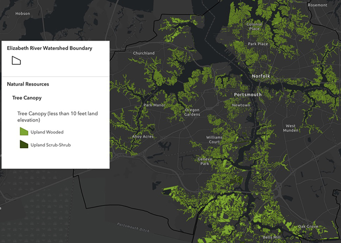
The Elizabeth River EJ Tool offers planners a wealth of data layers in its map viewer and dashboard. These include the location of Superfund and brownfield sites, as well as permitted outfalls for domestic sewage, FEMA flood data, urban tree canopy, potential wetland restoration opportunities, and industrial stormwater. For each U.S. Census block, the tool’s demographic layers show the percentage of low-income residents, people of color, people with less than a high school education, and individuals with English as a second language.
A “redlining” layer outlines Norfolk neighborhoods subject to historical mortgage practices that discouraged home-ownership by African-Americans, while infrastructure layers provide the location of law enforcement and medical facilities that could be helpful in planning an emergency response.
The tool also includes layers from the Shoreline Inventory developed by the Center for Coastal Resources Management at VIMS. These indicate existing shoreline protection measures and sites with public or private access to the water. Other environmental layers show public green spaces and “Natural and Nature-Based Features” such as salt marshes and freshwater wetlands. Typically less than 10 feet in elevation, these “NNBFs” offer multiple benefits to communities, including protection from tidal flooding. A sea-level-rise and storm-surge layer reveals the areas at greatest risk to this growing threat.
Indicator layers
While the many data layers incorporated in the Elizabeth River EJ Tool offer significant value to planners individually, perhaps their greatest value comes via the tool’s four “indicator layers,” which group selected layers into scorecards that show the Census blocks or tracts with the greatest overall vulnerability to environmental risks, demographic conditions, combined environmental and demographic factors, or hazards and toxins.
“We used a statistical analysis to generate vulnerability scores that reveal the combined distribution of 11 environmental stressors and 17 demographic indicators,” explains Mitchell. “Higher scores indicate that the census block is vulnerable to many stressors. Lower scores indicate that the census block is vulnerable to only one or two stressors.”
Garry Harris, chair of the Equity, Inclusivity, and EJ Task Force of the ERP board, says “It's going to be great to share this new tool with regulators, planners, and city councils. It really helps put us in a leadership position in terms of regional EJ and equity focus. A tool like this makes us the primary torch bearers and leaders for this important focus, not only in those affected communities but region-wide. "
ERP’s Watershed Action Team 2021 will use the online mapping tool as it works to update its strategy for community-wide action to improve the Elizabeth River in the next 5-10 years. “The tool will help all our community-wide partners direct restoration, education, and public-access efforts more intentionally to historically under-resourced communities in our watershed,” says Rieger.
