


Digging up the old garden...and a few spots we can't tell you about
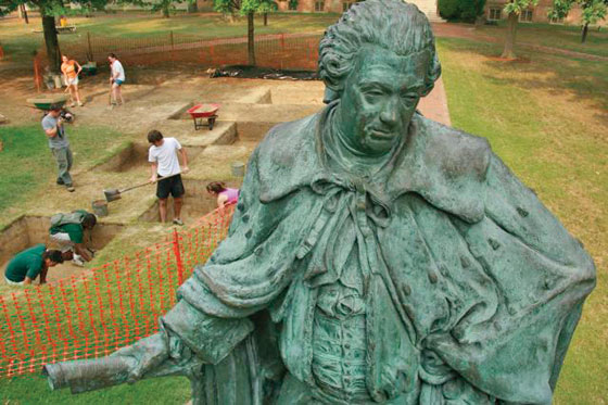 Behind Lord Botetourt's back A crew of student archaeologists spent three summers searching for evidence of formal gardens that were believed to grace the area in front of the Wren Building. They found at least some of what they were looking for.
From the most visible spot on campus to ultra-secret sites deep in the woods, our intrepid shovelers have been busy.
The campus just doesn’t look like it used to.
“I did not know that just digging can be interesting,” said Hiroaki Umehara.
Hiroaki was one of a half-dozen William and Mary undergraduates who spent the summer digging for evidence of former gardens in the College’s Wren Yard with anthropology instructor Steve Archer. Under Archer’s tutelage the students uncovered what appears to be evidence of an 18th-Century ditch, hedge rows and pathways.
“It’s a really well preserved cluster of features that align really well—the ditch and the planting holes, matching with the next line of at least one tree hole,” Archer said.
The Wren Yard surrounds the oldest building on the William and Mary campus, the Sir Christopher Wren Building. The building once housed the entire College and is still in use today as an academic building.
This summer’s excavation was the third conducted by student archaeologists under Archer’s guidance. Though the first dig turned up little, Archer wasn’t deterred. Last year’s dig was more fruitful—the team found evidence of topiary planting holes and some pathways. But this year’s finds have been the most impressive by far.
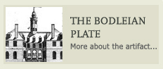 Recorded descriptions of the grounds appearance are few. One
possible view came to light in the late 1920s when researchers
discovered a printing plate in England’s Bodleian Library depicting the
Wren Building and its grounds. Still, little was known about the presence of the formal gardens
depicted in the plate until Archer’s teams began digging for evidence
two years ago. This year the team also found evidence of two closely
configured planting holes—one cutting into the other, Archer said.
Recorded descriptions of the grounds appearance are few. One
possible view came to light in the late 1920s when researchers
discovered a printing plate in England’s Bodleian Library depicting the
Wren Building and its grounds. Still, little was known about the presence of the formal gardens
depicted in the plate until Archer’s teams began digging for evidence
two years ago. This year the team also found evidence of two closely
configured planting holes—one cutting into the other, Archer said.
“You can actually see where one of the hedge plantings died and they had to dig it out and put in a new one,” Archer said. “It is, sort of a repair there to the hedging. You can actually sort of see them maintaining the garden a little bit, which is a neat find.” Archer, who is also a research archaeologist at the Colonial Williamsburg Foundation, noted they found other signs of the garden.
“We have sort of a consistent division where there is marl on the north half of these units (the digging squares) as we come down to the features but it’s not on the south half,” he explained. Archer noted that this marl would be consistent with an area depicted on the Bodleian Plate between the hedgerows flanking the center pathway.
With the answers to the mystery of the Bodleian Plate seemingly in hand, the team is turning its attention to what might have been the next design.
“What’s a little intriguing is that we keep getting hints that go in and out about what was happening out here in the late 18th Century,” Archer said.
The team also found evidence this summer of two diagonal walkways—one believed to be a 19th-Century path following a line that would have connected the Wren Building to the Brafferton and another 18th-Century path. Archer explained that the amount of fill found with the 18th-Century feature suggests that it was the active path between the Wren Building and the Brafferton in the latter part of that century.
“That means the formal garden would have been gone by then,” he said. “So we are trying to get the tail end of that Bodleian Plate design. It’s all little bits and pieces; you have to find out how everything fits together.”
The student archaeologists, some participating in a dig for the first time, enjoyed the opportunity.
“Archaeology has nothing to do with anything else I’m doing academically, but I enjoyed the change of pace,” said senior Caroline Lindsey. “It was also valuable to take advantage of W&M’s location and have an experience that is only possible in Colonial Williamsburg. I’ve done lots of undergraduate research through the Monroe Scholar program, but it’s always involved lots of time in the library. It was great trying something more hands-on.”
While Caroline was happy to be out of the library, others clamored to get in and do more research. The answers found by the archaeological evidence, as well as the new questions they raise, are the topic this semester of a special class taught at the College by Archer.
The class, Garden Archaeology, is taking a closer look at the artifacts discovered in this summer’s dig and, in some cases, looking for historical clues to support or refute theories on the summer’s findings.
“The class is a really good idea,” said senior Graham Callaway, one of Archer’s summer researchers. “It allows for questions to be asked of the data that an individual researcher would never have had time to ask.”
Each member of the three-credit class is designing their own research project. The topics range from examining the influence the introduction of the Brafferton had on the Wren Yard to researching the use of digital mapping to “unearth” archaeological features on the grounds.
The Wren Yard digs and class are supported by Board of Visitors Secretary Suzann Matthews, a member of the class of 1971.
While the research continues, Archer notes that a lot of progress has been made. He plans to present all the findings of the Wren Yard excavations and the classroom research in an exhibition and report in spring semester. Currently, there are no plans for further excavations in the Wren Yard--“leaving that,” he says, “for future generations.”
--Suzanne Seurattan
...and meanwhile, somewhere along the Colonial Parkway
“I’m intentionally going to be a little vague,” warns Joe Jones, director of William and Mary’s Center for Archaeological Research, as he sits down to discuss the center’s latest project.
 It isn’t that he’s modest, but there are risks when
archaeological efforts or results are widely publicized. “People might
try to identify new areas where they could go dig up stuff to sell on
eBay,” says Jones. Not only are such practices bad for archaeology, he
said—they’re also illegal.
It isn’t that he’s modest, but there are risks when
archaeological efforts or results are widely publicized. “People might
try to identify new areas where they could go dig up stuff to sell on
eBay,” says Jones. Not only are such practices bad for archaeology, he
said—they’re also illegal.
Jones and his colleagues are continuing their systematic quest for buried historic—and prehistoric—sites on federally owned parkland along the Colonial Parkway that stretches between Jamestown and Yorktown. The archaeologists are about three months into what may become a four-year survey commissioned by the National Park Service.
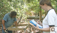
The procedure for visiting a team in the field has an air of mystery. You park at a prescribed place along the 23-mile Colonial Parkway and punch a number into your cell phone. Someone answers. You identify yourself, then lean against your car fender until Elizabeth Monroe walks out of the woods to guide you in to where the shovel testing is going on.
“We’ve excavated well over 2,600 shovel tests at this point,” says Project Archaeologist Monroe. Shovel testing is a kind of an archaeologist’s version of the board game Battleship—digging numerous small holes in a grid to identify potentially significant sites.
“We have identified at least 21 sites, which include 18th- and 19th-Century farmsteads or plantations, Civil War-era earthworks and 20th-Century recreational facilities,” Monroe added.
Jones said that workers have located evidence of Native American occupation on some of these land forms out near College Creek during the Middle Woodland period, which dates between approximately A.D. 300 and 1000 in Virginia.
The process is slow and the funding somewhat unpredictable. Though
Jones hopes that the full slate of appropriations will be realized over
four years, funding is linked to federal fiscal  year budgets so it is
allocated in installments.
year budgets so it is
allocated in installments.
“This means,” says Jones, “that the work is done one segment at a time, within specific parameters provided by the Park Service.”
It is a close and complementary collaboration with the Park Service—one that Monroe describes as “extremely gratifying.”
“Every week we make copies of our field-maps and Park Archaeologist Andrew Veech and Geographic Information Systems specialist Dave Frederick locate our positive shovel tests in the field, using a GPS device to record their locations,” Monroe said. That information can then be used to place the clusters of positive shovel tests—or sites—on modern maps for planning purposes.
“But it is also possible to overlay them on historic maps which can help identify historical associations for the sites we’re finding,” she said.
The Park Service boasts an extensive collection of map resources which leads to other research possibilities. The survey team can, for instance, evaluate the sites they are finding by their proximity to fresh water, types of soils, elevation above mean high tide or slope—and predict where other sites might be found on similar settings outside of the parkway.
For the time being, however, the team will continue its work along the parkway—sometimes beyond the woods’ edge and other times close enough that they are able to view the occasional parade of Model A cars motoring by.

