


Data Recovery Excavation Methods
 An unusual archaeological aspect of Site 44JC969 was the apparent lack of postoccupational plowing, unlike most relatively level areas throughout the Tidewater region. While the absence of a deep plowzone implies that shallow cultural deposits may retain more archaeological integrity than on a plowed site, it also makes it difficult to distinguish the uppermost deposits of feature fill from the overlying topsoil layers. In the area of Structures 2 and 4, for example, excavation uncovered a large amorphous area with an uneven, gradual transition to the subsoil below. At first this soil deposit was interpreted as a single, broad, shallow depression that had filled with trash during occupation of the site. Later, though, this artifact-rich deposit was found to seal multiple subfloor pit features of various ages as well as other primary structural remains such as hearth and chimney support features. The blanketing cultural deposits likely represent both the debris of daily living (primary occupational deposits) and the decayed remnants of structures.
Once the original grid from the evaluation was reestablished, three block excavations of 6.6 × 6.6 meter (2 × 2 meters) test units were begun. To ensure adequate recovery of artifacts, most soil from test units was screened through 1/4-inch wire mesh. The top two layers, Strata I and II defined during the evaluation, were removed from each unit as a single context. Strata I and II were screened in more than half of the test units; in the remaining units the two upper strata were not screened except for six quarter sections (3.3 × 3.3 feet [1 × 1 meter]). A trench measuring 36 × 6.6 feet (11 × 2 meters) was hand-excavated without screening in an attempt to identify additional features associated with one of the structures at the site (Structure 1). The soil was removed with shovels and the surface troweled to expose any features that might be present.
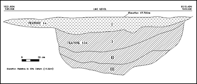
Features revealed during test unit excavation were investigated following a standardized procedure. Each was first recorded in plan with scale drawings and photographs. In the case of nonlinear features, one half of the feature was excavated, with soil samples retained as warranted. After the cross-section profile was recorded, the other half of the feature was excavated and screened as well. Black-and-white photographs and color slides were taken of all test units, profiles, and excavated features. Natural soil layers were designated with Roman numerals; arbitrary levels within natural strata were designated with lowercase letters (IIa, IVc, etc.).
