


Background and Methods
 Excavations at Southall's Quarter took place on a portion of a site that was designated 44JC969. Besides representing a small complex of eighteenth-century slave cabins, Site 44JC969 also includes a brief prehistoric occupation and remnants of a dwelling area dating as far back as the mid- to late seventeenth century.
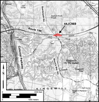
The area for intensive data recovery excavation was limited to the 1.5-acre eighteenth-century portion of the site north of Route 199, where road widening activities would occur. Site 44JC969 is situated on a broad, wooded terrace, less than a mile east of the Colonial National Historical Parkway, at an elevation of 69 feet above mean sea level. The site is bisected by Route 199 along its east-west axis and is cut by Mounts Bay Road near its western edge.
The site is generally flat, with a gradual slope from northeast to southwest. More extreme slopes are present just north and south of the Mounts Bay Road/Route 199 intersection. Site soils are part of the Kempsville-Emporia complex (Hodges et al. 1985). The site was covered with mature, secondary-growth, mixed hardwood forest consisting of young and mature oak, pine, poplar, and beech trees. Numerous tree stumps indicated the area had been timbered recently.
