


Landscape
 The houses, privies (outhouses), and other structural elements at Sites
44PY178 and 44PY181 were built and maintained by the company (Thompson
1984:25–27). Mill housing undoubtedly provided some degree of
comfort, although the unwavering cost-efficient construction of most company
houses often resulted in poor quality, comfort, and appearance, especially
over the long run (Beardsley 1987:45,
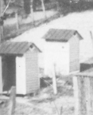
46). The homes along Front Street were painted white and had either
red or green tin roofs, as was typical for other Dan River Mill houses.
The privy was painted to match the house. Housing and landscape conditions
created images forever burned into memories of childhood, as recounted
by one South Carolina native's recollection of Winnsboro during his youth:
The houses, privies (outhouses), and other structural elements at Sites
44PY178 and 44PY181 were built and maintained by the company (Thompson
1984:25–27). Mill housing undoubtedly provided some degree of
comfort, although the unwavering cost-efficient construction of most company
houses often resulted in poor quality, comfort, and appearance, especially
over the long run (Beardsley 1987:45,
46). The homes along Front Street were painted white and had either
red or green tin roofs, as was typical for other Dan River Mill houses.
The privy was painted to match the house. Housing and landscape conditions
created images forever burned into memories of childhood, as recounted
by one South Carolina native's recollection of Winnsboro during his youth:
dreary lot of unkempt, unpainted houses on a hilly spot south of town....Thin gray lines of smoke issued from kitchen chimneys in the daytime, and yellow kerosene lamp lights shone out of the small windows at night....The persons making their way through its unkempt streets sometimes would have to hold their noses to keep out of the stench of pig pens or cow stalls (Beardsley 1987:45).
Some mill families actively sought to improve the appearance of their yards, and reap the potential benefits through the planting of flower beds and small kitchen gardens. This may have involved drawing upon agricultural backgrounds to transform rented properties into “urban farmsteads” on which they grew vegetables and fruit, and raised small animals. This was probably not the norm, however, and does not appear to have occurred extensively, if at all, at Sites 44PY178 and 44PY181 (Stottman 2000:56). As described above, backyard sanitation practices on the Front Street sites most likely hindered tenant aspirations to garden. The scattering of privies and slop holes probably left little room for gardening. On the farm residents would have built their own privies and placed them at convenient locations of their choosing. They would have had ample room to relocate them when necessary, but as tenants on small urban lots, their options were far more limited.
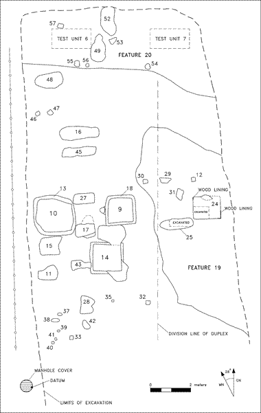
The site plans of 44PY178 and 44PY181 depicts the many traces of human habitation left from the 1890s through 1950. Analysis of the features and their contents allows us to interpret how the yards of the Front Street mill houses appeared during that period. Combining this information with the written record, we can then get a better sense of the living conditions of the mill workers who lived here.
Site 44PY178 included postholes, a brick walkway, ditches, foundations, and privies, among other features. Two parallel ditches (Features 11 and 22) were probably among the earliest features on that site, and these may have even preceded site development in 1894. These culturally sterile features may have been necessary to improve drainage in the Front Street area as it was developed. An early twentieth-century brick walkway was located along the east boundary of the property. It provided access to privies toward the rear of the lot, and to steps that descended to North Main Street. This route was most likely taken by occupants of Site 44PY178 and perhaps other residents of Front Street as they made their way to work in the mill. Privies were located a few meters west of the walkway and approximately 12 m (39 ft.) behind the house. Four privy pits (Features 1 and 6–8) were discovered. These typically measured 1.5 × 1.5 m (5 × 5 ft.), were 40–70 cm (1.31–2.29 ft.) deep, bottomed out on bedrock; all of these were originally wood-lined. Dates of the most recent aritifacts discovered in each feature suggest that features were abandoned during the Depression and post-Depression periods when the site property was occupied by the Snead, Barnes, and Strider families, among others. Builders trenches for the privies do not provide clues to specific construction dates, but some of the privies probably were used by the earliest families such as the McQueens, Pruits, and others. At least two privies, one for each household in the duplex, probably existed at the same time. However, archaeological evidence indicates that these privies may not have been sufficient to meet the sanitary needs of the occupants, especially as activity intensified on the property beginning in the 1920s. At least five less formal pits clustered near the privies probably served as simple slop holes, and several of these contained “night soil” like their privy counterparts.
The appearance of the Site 44PY181 backyard was generally similar to Site 44PY178. Archaeology revealed several wood-lined privies and informal slop holes dating mainly to the early twentieth century, but some may have been used as late as 1950. Most features were clustered about 10 m (33 ft.) behind the house. A possible storage shed, or some other type of outbuilding, may have stood just northeast of the privies based on the presence of concrete footers (Features 12 and 30) and possible building-related stones (Features 29 and 31). An alleyway was located just north of this structure at the rear of the lot. Insurance maps indicate that this corridor was probably a service alley that existed by at least 1899 and was abandoned and/or removed by the late 1940s. Remnants of either this alleyway, or a possible earlier nineteenth-century road trace, may be represented by Features 21 and 23. The alley provided access to the properties for the removal of toilet waste and trash, and the unloading of coal and wood (Thompson 1984:26). The back portion of the lot near the alley may have been well shaded, based on the presence of several large tree holes (i.e., Features 8, and 48–52).
The distribution of features and artifacts provide clues about backyard development over time, and the implications for tenants at Site 44PY181. The earliest traces of activity were found at the rear (north) of the property and along its eastern boundary. The rear of the yard included possible nineteenth-century road traces, shade trees, and nineteenth-century domestic artifact scatter. The eastern area contained a scatter of nineteenth-century artifacts and early twentieth-century materials associated with a privy (Feature 24) and a slop hole (Feature 25). According to the distribution of these artifacts, we can assume residents intentionally discarded some of their trash in these areas. Regular, organized garbage collection seems to have been the norm, however, from very early on. This is indicated by the absence of early trash pits and the late abandonment dates for privies.
Privy cleaning, as practiced in Danville’s mill community and in other mill communities, contrasts sharply with on-site human waste disposal practices during the first half of the twentieth century (Adams et al. 1993:63). Privies and slop holes at Site 44PY181 generally were clustered on either the eastern and western halves of the yard, consistent with the arrangement of space in the duplex at the Front Street 100 and 102 addresses. Most of the features were concentrated on the west (Lot 102), perhaps reflecting the larger number of households that resided there over time. There was no evidence of a fence separating the backyard into halves, as might be expected, which suggests a mutual understanding existed between tenants concerning the use of this space. Overall, space may have been more communal than restrictive. Use of the area for toilets and waste disposal (from chamber pots and slop jars) from the duplex likely broke down barriers of private yard space, especially as sanitation demands increased during the pre-Depression and Depression eras. The privies were typically abandoned during the 1930s and 1940s. The similar abandonment dates, coupled with few datable clues from builder’s trenches, make it difficult, if not impossible, to determine which may have been built first. However, end dates from abandonment fill suggest that two or more privies probably coexisted, and were regularly cleaned to extend their use life.
The yards of the Front Street tenants may have been similar to those of Schoolfield Village. Each dwelling in the mill village had a small front yard and a larger back yard, with a privy usually located about 50 ft. from the back door. For some households, sanitation was not a primary concern. Some tenants even may have discarded waste out of windows (Thompson 1984:26). Backyards often included gardens, cow sheds, flower beds, and grape arbors. These elements could have existed behind the Front Street residences, but the extent of sanitation-related activities, as evidenced by privies and slop holes, may have limited these other uses for the yards.
