


Archaeology
Understanding the landscape of past human activity at the Chiles Homesite.
 At the request of the Bureau of Land Management, Eastern States Office, the William & Mary Center for Archaeological Research undertook an archaeological study of the Chiles Homesite and the surrounding area. This evaluation took place during the spring of 2005 through several site visits. The Chiles Homesite is known to archaeologists through its official site number, 18CH748. This number corresponds to the state (listed alphabetically with Maryland 18th), the county (CH=Charles County), and the number of sites identified within the county (Chiles Homesite is the 748th).
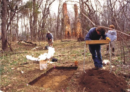
To begin to understand the site extensive historical background research was conducted. Since many other people have inhabited this landscape it is necessary to investigate who they were, where they have lived, and what they were doing. In order to do this a series of shovel tests pits (STP) were excavated across the site to find buried material culture (artifacts) and/or features (building foundations, filled-in holes, trash pits, etc.). Shovel testing allows archaeologists to gather information about a large area quickly, and without disturbing large areas of the site. It involves digging small holes (about the diameter of a dinner plate) at regular intervals, sifting the removed soil for artifacts, and noting the layers of soil visible in the sidewalls of the holes. These tests are usually excavated through layers of soil that are shallow enough to bear traces of human activity.
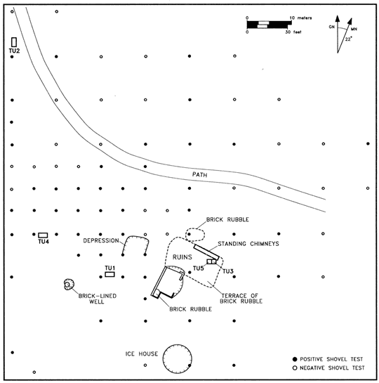 Armed with knowledge from historic documents and the reports of architectural historians Foreman and Rivoire, it was expected that the remains of several outlying structures would be found during survey. Among them, a kitchen, smokehouse, slave quarters, a brick-lined well, and icehouse. Indeed, archaeological survey located some of these features. The area to the northwest of the house contained a high density of positive, or artifact-rich, shovel tests. Artifacts from this area confirmed the presence of late 18th century to 20th century artifacts, matching the date range for occupation of the house.
Photo left: Map of the Chiles Homesite showing locations of shovel tests, test units and major surface features.
Once the shovel tests had been dug and a map was made of them, concentrations of positive-STPs could be lumped into areas of high artifact concentration. When these were compared to topographical changes such as slopes on the site and known feature locations (such as the well and icehouse), the archaeologists proceeded to excavate a series of five test units on-site. The test units are areas where the soil is carefully removed to reveal subsurface artifacts and feature stains. Since these test units were placed in areas of known artifact concentrations, each test unit uncovered something of significance.
