


Life during wartime
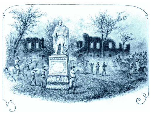 Move-in day, 1863 Lord Botetourt stays above the fray as Confederate raiders clash with Union occupiers of William & Mary’s campus during the Civil War with the ruins of the Wren Building in the background. The image was made by David E. Cronin, Union provost marshal, during the occupation of Williamsburg. Archaeologists have uncovered remains of Yankee fortifications. Collection of the New York Historical Society, negative #57996
Archaeologists uncover remains of a fortified William & Mary
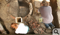
Archaeologists working in the university’s Brafferton Yard have uncovered evidence of a time a century and a half ago in which the normally placid Historic Campus was a Civil War battleground.
For much of the War Between the States, Williamsburg—and the William & Mary campus—were near the frontier between the Union-controlled lower Peninsula and the Confederate upper portion. The William & Mary Center for Archaeological Research (WMCAR) has excavated a small plot south of the Brafferton Kitchen that is crowded with features dating to the occupation of campus by Union troops from 1862-1865.
 The findings are in accord with historical accounts of the period, which was marked by a cavalry raid by Confederates, the burning of the Wren Building by a Pennsylvania unit and the metamorphosis of the campus into an armed camp. No classes were disrupted, though—William & Mary had suspended operations before the outbreak of hostilities.
WMCAR Director Joe Jones says his archaeologists have uncovered remains of ditches that marked palisades erected by the Union troops in 1865 to defend their position against possible attacks by Confederates from the west. There was apparently a fear that the Confederates might try to move east and down the Peninsula after Richmond and Petersburg fell into Union hands in 1865. The site also holds remains of a well dug, then apparently abandoned, by the occupying troops. WMCAR also has uncovered the remains of a foundation of a previously unrecorded outbuilding that Jones believes predates the Civil War and may have been dismantled for building materials by the federal troops.
Artifacts of life in a Union army camp
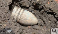
The archaeologists have removed a number of supporting artifacts from the site, including an unfired Minié ball, a common Civil War rifle round. A number of clay marbles may be remnants of the leisure activities of the occupiers. WMCAR has also found a number of buttons, including a fine Confederate-issue button from a Virginia regiment. A gold-amalgam pen nib also was recovered, still shiny after all these years, once the dirt was wiped off.
Jones notes that the WMCAR findings are in accord with an 1865 account to the William & Mary Board of Visitors by President Benjamin Stoddard Ewell, republished in a 1928 issue of the William and Mary Quarterly.
 “If you read it carefully, President Ewell talks about defensive works thrown up across the campus between the ruins of the Wren Building, the Brafferton and the President’s house,” Jones said. “He specifically mentions the southeast and the northeast corners of the Wren Building’s remains connected to the Brafferton and the President’s house respectively. Then, he makes a point of saying that all of that was flanked by palisades that extended from the Brafferton out across Jamestown Road, or what he called Mill Road, and the President’s House out across Richmond Road.”
Palisades not very different from those used at Jamestown
Jones noted that the defensive palisades were described as being constructed from 10-foot logs set vertically in ditches three feet deep.
“In general appearance, they’re not that different from what they had at the Jamestown fort over two centuries earlier, though the construction details are quite different,” he said. The direction the ditch runs strengthens the case for it marking the course of the palisade, he added.
“The thing about a line like that, it’s built according to the kind of strategic and engineering principles they used to put up earthworks and fortifications,” Jones explained. “There’s a priority on aligning that palisade so that it gives the people defending it a field of fire across the largest area where the enemy might be coming in across the landscape. So you wouldn’t want a palisade that goes perpendicular to Jamestown Road—you’d want to have an angle for a flanking fire.”
Ewell was no doubt quite accurate in describing the Union fortifications to the board; he was a West Point graduate and an officer in the Confederate army. Jim Whittenburg, education director of William & Mary’s National Institute of American History and Democracy (NIAHD), notes that Ewell designed the defensive fortifications used during the May 5, 1862 Battle of Williamsburg.
Whittenburg explained that Williamsburg marked a high-water point of Union forces that tried to capture Richmond by marching up the Peninsula from Fort Monroe in Hampton. Following the Battle of Williamsburg, Union forces occupied the town and were quartered on the William & Mary campus.
Emancipation Proclamation notes area’s strategic status
He also points out that Williamsburg’s strategic status is indirectly acknowledged by no less a document than Abraham Lincoln’s 1863 Emancipation Proclamation.
“The Emancipation Proclamation of 1863 specifically excludes York County. It doesn’t apply there. It’s written right into the Emancipation Proclamation itself and I have my students read it. The reason is that the proclamation does not apply in areas that are under Union control,” Whittenburg explained. He noted that the Emancipation Proclamation most famously exempted border states that had not voted to secede, but he says the document also included other lesser-known exemptions.
“There are some counties in Virginia and some parishes in Louisiana where the Emancipation Proclamation did not hold force,” he said. “These were specific little areas that the Union had conquered and they were considered ‘pacified’. But it did apply in James City County and Williamsburg and the funny thing is that they’re right next door to York County.”
WMCAR found the remains of the well during the fall of 2011, while conducting test excavations ahead of utility line work related to the scheduled renovation of the Brafferton, a university building that dates to 1723 and was home to William & Mary’s Indian school. Additional funding secured by Louise Kale, executive director of William & Mary’s Historic Campus, allowed WMCAR to reopen and expand the site this summer.
Jones notes that interpretation of the dig presents a number of challenges. The dig isn’t large—about 12 by 20 feet—but it is packed with archaeological remains of various structures and developments, many of which were built on top of one another at different times. The excavated area also includes a PVC drain line and an earlier, tile drain likely from the early 20th century, long disused. The result of having so many features crowded in one small space is what Jones calls a set of “head-scratchers.” For instance, a ditch feature, partially filled with brick rubble, intersects the well. WMCAR archaeologists believed when it was first uncovered that the well was dug after an earlier brick wall set in the ditch had been torn down.
“But now it seems clear either that they had backfilled that well some time before they dug the ditch or maybe they just dug that ditch right over the top of where they had recently backfilled the well,” he said. “They put up these defenses fairly quickly.”
The archaeology corresponds with the history—generally
Jones said that further analysis will clarify the sequence of when each of the features was constructed. Drawing on Ewell’s accounts and a book written as a master’s thesis at William & Mary, Defend This Old Town, by Carol Kettenburg Dubbs, Jones believes that the archaeology is consistent with Ewell’s account of defensive works connecting the standing buildings—the Brafferton, the President’s House and the remains of what we now know as the Wren Building, plus some outbuildings, “some of the door ways & windows being blocked up & loop-holed,” as Ewell’s report reads.
“We think the general sequence that we’ve interpreted is correct, but there are some details of archaeological relationships between features that complicate certain aspects of the general interpretation,” he said. He noted that ongoing excavation and consultation of documentary sources should bring the picture more nearly into focus.
The dig, prominent and conspicuous near the Brafferton, has been a popular site for tourists and other visitors. WMCAR developed an informational flyer to give out to interested visitors. The dig is scheduled to remain open until Aug. 6, at which point the area will be backfilled. ![]()
Image of Wren Yard skirmish: Collection of the New-York Historical Society, negative #57996
