
Archaeologists believe they've found a Civil War-era well
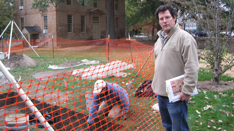
The mist turns into a legitimate drizzle as Joe Jones stands over a hole in the ground on the Historic Campus of William & Mary. He has just removed a large plywood cover sheltering a pit approximately two feet in depth.
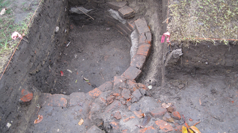
The pit reveals the remains of what Jones believes was a well constructed during the Civil War occupation of campus. Immediately adjacent are the archaeological remnants of what the archaeologists suspect was originally a brick wall that could have marked the campus boundary. A few yards south, archaeologists exposed part of a more extensive, buried deposit of crushed oyster shell and brick fragments. Jones suspects these remains may mark the northern edge of an early historic course of Jamestown Road. It’s several yards north of the course of the present Jamestown Road.
Jones and other archaeologists from the William & Mary Center for Archaeological Research (WMCAR) found these remains just to the south of the Brafferton Kitchen. WMCAR is investigating the significant archaeological resources in the area in coordination with excavations by contractors installing new underground utility lines across campus.
Jones, the director of WMCAR, says there are two reasons for believing that the well dates to the Civil War occupation of campus. For one thing, initial observations indicate that well contains artifacts that date to the Civil War period, including “Minié balls” (lead bullets used during the conflict). He added that backfilled wells often contain artifact deposits, creating a sort of “time capsule” that reliably fixes the point in time that the well was abandoned and filled.
Secondly, the lining of the well, Jones says, was built from reused rectangular brick, mixed with roughly dressed fieldstone, materials likely taken from dismantled or destroyed campus buildings and walls. He explains that tapered bricks were traditionally used to construct circular well linings.
“The use of recycled rectangular bricks together with pieces of dressed fieldstone suggests that the well was constructed somewhat hastily using scavenged materials,” Jones said. “This is consistent with general expectations of archaeological resources that would date to the Civil War military occupation of the campus.”
Remains of a brick and sandstone wall lead up to the well. Jones notes that the feature seems to parallel Jamestown Road, which makes him speculate that it could be a boundary wall, “but really, there are a lot of other things it could be.”
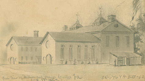
Jones noted that an interpretation of the oyster-shell remains are consistent with period maps of Williamsburg. He explained that present-day routes of early Colonial roads do not always follow the original courses exactly. He said that poor drainage of unpaved roads often prompted users to cut multiple, parallel, tracks around especially muddy or ruddy section, causing the roadway to “wander” over the years, until finally fixed by paving.
Jones speculates that this phenomenon explains why the 1782 Desandrouin Map of Williamsburg, for example, portrays two parallel tracks for Jamestown Road at that time, one of which is shown to pass much closer to the Brafferton than today’s Jamestown Road. The Frenchman’s Map also depicts Jamestown Road nearly nicking the corner of the Brafferton.
These discoveries come on the heels of work led by William & Mary Ph.D. student Mark Kostro, who earlier this summer excavated a trench at the base of the Brafferton and yielded new insights on the history of the 288-year-old building.
Also this summer, WMCAR uncovered a set of brick foundations near the Wren building. Jones described them as a “substantial outbuilding or dependency,” probably occupied and/or used by the enslaved staff of the College in the 18th century.